搜索结果: 1-15 共查到“物理大地测量学”相关记录130条 . 查询时间(4.054 秒)

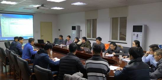
2018年12月29日,中国科学院测量与地球物理研究所大地测量与地球动力学国家重点实验召开卫星重力/测高监测湖泊等陆表质量变化专题研讨会。研究员闫昊明、副研究员张子占和冯伟主持了报告会。测地所副所长倪四道、副所长王勇,副研究员詹金刚等参加会议,会议邀请到武汉大学、南京大学、华中科技大学和中科院上海天文台等单位和本单位的专家和研究生报告了相关领域的研究进展和成果。 武汉大学钟波副教授介绍了GRACE...
山东大学科技期刊社四期刊获中国高校期刊奖励
山东大学科技期刊社 四期刊 中国高校 期刊奖励
2018/11/20
2018年11月5日,中国高校科技期刊研究会公布了2018年度全国高校“杰出·百佳·优秀科技期刊”评选结果。山东大学科技期刊社编辑出版的《山东大学学报(理学版)》被评为“中国高校百佳科技期刊”;《山东大学学报(医学版)》《山东大学学报(工学版)》《山东大学耳鼻喉眼学报》被评为“中国高校优秀科技期刊”。近年来,科技期刊社紧紧围绕学校“双一流”建设,以创建“名刊强社”为目标,认真谋划发展蓝图,实施“期...

近日,《中国科学:地球科学》第十一届编委会第一次会议召开,会议遵循科学计量指标定量评价与同行专家定性评审相结合的原则,从每个学科中仅遴选出1篇“热点论文”。兰州大学资源环境学院西部环境教育部重点实验室青年教师黄伟和陈发虎院士等在2015年发表的题为“Definition of the core zone of the “westerlies-dominated climatic regime”, ...

应中科院低温工程学重点实验室和理化所公共技术服务中心邀请,英国国家物理实验室(NPL) Graham Machin教授于2017年10月10日至11月10日来理化所开展了为期一个月的访问交流。
NOVEL SNOW DEPTH RETRIEVAL METHOD USING TIME SERIES SSMI PASSIVE MICROWAVE IMAGERY
Snow Depth Support Vector Regression Nonlinear Modeling Genetic Algorithm band combination
2016/11/30
The Special Sensor Microwave Imager (SSM/I) and the Special Sensor Microwave Imager Sounder (SSM/IS) are satellites that work in passive microwave range. The SSM/I has capability to measure geophysica...
DETECTION AND DISCRIMINATION OF THE THICK OIL PATCHES ON THE SEA SURFACE
Oil slick thickness offshore slick SWIR VNIR optical multispectral data hyperspectral characterization reflectance spectra
2016/11/30
Detection of natural or accidental oil slick at sea surface is important both for exploration purposes and for environment protection. Radar imagery, either satellite or airborne is the prime tool to ...
GEOLOGICAL MAPPING USING MACHINE LEARNING ALGORITHMS
Geology Geological Mapping MLA Random Forest Spectral Imagery Rocks
2016/11/30
Remotely sensed spectral imagery, geophysical (magnetic and gravity), and geodetic (elevation) data are useful in a variety of Earth science applications such as environmental monitoring and mineral e...
GEOLOGICAL MAPPING BY COMBINING SPECTRAL UNMIXING AND CLUSTER ANALYSIS FOR HYPERSPECTRAL DATA
Geology Mineral Unmixing Cluster Analysis Hyperspectral Cuprite
2016/11/30
Spectral unmixing of hyperspectral data often fails to select some minerals and rocks having flat spectra but no diagnostic absorption features as endmembers, even if they are actually important endme...
ANOMALY IDENTIFICATION FROM SUPER-LOW FREQUENCY ELECTROMAGNETIC DATA FOR THE COALBED METHANE DETECTION
Electromagnetic Super Low Frequency Coalbed Methane non-Gaussian Class B model Least Square Gradient Adaptive filter
2016/11/30
Natural source Super Low Frequency(SLF) electromagnetic prospecting methods have become an increasingly promising way in the resource detection. The capacity estimation of the reservoirs is of great i...
Sensitivity of land surface and Cumulus schemes for Thunderstorm prediction
Mesoscale Parameterization Microphysics Grid-scale
2016/11/30
The cloud processes play an important role in all forms of precipitation. Its proper representation is one of the challenging tasks in mesoscale numerical simulation. Studies have revealed that mesosc...
THE FRAMEWORK ON MULTI-SCALE LANDSLIDE HAZARD EVALUATION IN CHINA
Scale Framework Landslide susceptibility Physically based model Process Evaluation
2016/11/30
Nowadays, Landslide has been one of the most frequent and seriously widespread natural hazards all over the world. How landslides can be monitored and predicted is an urgent research topic of the inte...
ESTIMATION OF REGIONAL FOREST ABOVEGROUND BIOMASS COMBINING ICESAT-GLAS WAVEFORMS AND HJ-1A/HSI HYPERSPECTRAL IMAGERIES
LiDAR ICESat-GLAS Waveform HJ-1A/HSI Hyperspectral imagery Forest aboveground biomass Support vector machines
2016/11/24
Estimation of forest aboveground biomass (AGB) is a critical challenge for understanding the global carbon cycle because it dominates the dynamics of the terrestrial carbon cycle. Light Detection and ...
POLARIMETRIC SIGNATURES IDENTIFICATION FOR DIFFERENT FEATURES IN RADARSAT-2 POLSAR IMAGE:A CASE STUDY OF HALAYIB AREA,EGYPT
Radarsat-2 PolSAR Polarimetric signatures Pauli decomposition Co-polarization and cross-polarization signature
2016/11/24
In fully polarized SAR (PolSAR) data the returned signal from a target contains all polarizations. More information about this target may be inferred with respect to single-polarization. Distinct pola...
COMPREHENSIVE SPECTRAL SIGNAL INVESTIGATION OF A LARCH FOREST COMBINING GROUND-AND SATELLITE-BASED MEASUREMENTS
Data Fusion Spectral Signal Field Spectrometry Landsat 8 OLI Classification Larix decidua
2016/11/23
Collecting comprehensive knowledge about spectral signals in areas composed by complex structured objects is a challenging task in remote sensing. In the case of vegetation, shadow effects on reflecta...
MULTIPLE REFLECTION EFFECTS IN NONLINEAR MIXTURE MODEL FOR HYPERSPECTRAL IMAGE ANALYSIS
Hyperspectral images Linear mixture model (LMM) Generalized bilinear model (GBM) Modified generalized bilinear model (MGBM)
2016/11/23
Hyperspectral spectrometers can record electromagnetic energy with hundreds or thousands of spectral channels. With such high spectral resolution, the spectral information has better capability for ma...

