搜索结果: 1-15 共查到“工学 fires”相关记录32条 . 查询时间(0.064 秒)
REMOTE SENSING & GIS INTEGRATION FOR MONITORING THE AREAS AFFECTED BY FOREST FIRES: A CASE STUDY IN IZMIR, TURKEY
Remote Sensing Forest Fire Burn Indexes Classification Sentinel Landsat, DEM
2018/4/18
A forest fire is stated as an ecological disaster whether it is man-made or caused naturally. İzmir is one of the regions where forest fires are most intensified in Turkey. The study area located...
REMOTE SENSING & GIS INTEGRATION FOR MONITORING THE AREAS AFFECTED BY FOREST FIRES: A CASE STUDY IN IZMIR, TURKEY
Remote Sensing Forest Fire Burn Indexes Classification Sentinel Landsat DEM
2018/5/8
A forest fire is stated as an ecological disaster whether it is man-made or caused naturally. İzmir is one of the regions where forest fires are most intensified in Turkey. The study area located...

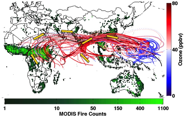
Fires Burning in Africa & Asia Cause High Ozone in Tropical Pacific(图)
Fires Burning Africa Asia High Ozone Tropical Pacific
2016/1/22
While efforts to limit ozone precursor emissions tend to focus on industrial activities and fossil fuel combustion in the United States and China, a new University of Maryland-led study suggests that ...
STUDIES ON EMISSIONS FROM FOREST FIRES USING MULTI-SATELLITE DATASETS OVER NORTH EAST REGION OF INDIA
Atmosphere Climate Change Forest fires biomass burning Satellite data
2015/12/28
Tropical biomass burning and associated emissions of aerosols into the atmosphere play a vital role in atmospheric perturbation and climate change. Aerosols containing black carbon are emitted primari...
BURNED AREA, RECURRENCE OF FIRES AND PERMANENCE OF BURNT SCARS IN SELECTED AREAS OF THE BRAZILIAN CERRADO USING TM-LANDSAT IMAGERY
Forest Fire Land Cover GIS Monitoring Multitemporal Spati
2015/7/29
A study was conducted in two selected areas of the Brazilian cerrado using Landsat imagery during a five years period (1996-2000),
to address the following estimation issues: (1) burnt area using sta...
Topographical classification in the prediction of disaster zones in forest fires using DTM
Terrain classification and prediction disaster the forest fire
2015/2/5
Topographical classification in the prediction of disaster zones in forest fires using DTM.
MULTITEMPORAL LANDSAT TM DATA FOR MONITORING THE EFFECTS OF FOREST FIRES AND VEGETATION RECOVERY PROCESSES IN MEDITERRANEAN AREAS
Multitemporal landsat TM data monitoring
2015/2/4
MULTITEMPORAL LANDSAT TM DATA FOR MONITORING THE EFFECTS OF FOREST FIRES AND VEGETATION RECOVERY PROCESSES IN MEDITERRANEAN AREAS.
CHANGE DETECTION ON NATURAL VEGETATION COVER IN THE TERITORY OF I.R.OF IRAN CAUSED BY POLLUTION RESULTED FROM THE KUWAITI OIL WELL FIRES,DURING THE PERSIAN GULF WAR
Image processing Change detection Persian Gulf war vegetation cover
2015/2/3
Burning of nearly 700 Kuwaiti oil wells and storage tanks during the Persian Gulf war made a severe
impact on the environment of the region by emitting about 5000 tons of smoke daily. The fall out o...
DETECTION OF CHANGES IN FOREST LANDCOVER TYPE AFTER FIRES IN PORTUGAL
Landsat TM forest fires vegetation indices land cover change multitemporal analysis
2015/2/3
We present a methodology to detect terrain mobilization in the years following a fire using multitemporal Landsat TM imagery. Furthermore, we show the spectral evolution of the land cover since fire o...
Utilizing Multi-Sensor Fire Detections to Map Fires in the United States
Forest Fire Mapping Change Detection Landsat Multisensor Data Mining
2014/12/4
In 2006, the Monitoring Trends in Burn Severity (MTBS) project began a cooperative effort between the US Forest Service (USFS) and the U.S.Geological Survey (USGS) to map and assess burn severity all ...
SYNERGISTIC USE OF OPTICAL AND RADAR DATA FOR RAPID MAPPING OF FOREST FIRES IN THE EUROPEAN MEDITERRANEAN
Forest fire SPOT 5, TerraSAR-X burned area mapping
2014/6/5
In a classical approach, optical data are being used for forest fire detection in a rush mode. Difficulties arise due to persistent cloud
coverage, haze layers and smoke plumes. In contrast, radar m...
Modelling of Environment Vulnerability to Forests Fires and Assessment by GIS Application on the Forests of Djelfa (Algeria)
Forest Fire Vulnerability Model Djelfa GIS
2013/3/5
Risk management of forest fires starts from its assessment. This assessment has been subject of several research works and many models of fire risk have been developed. One of them has been developed ...
For the last 20 years blackouts have been included in the list of major disasters that includes storms, hurricanes, earthquakes and floods. Therefore consumers have become increasingly aware of fires ...
Geospatial Model as Strategy to Prevent Forest Fires: A Case Study
Viewshed Analysis Watchtowers Forest Fires
2013/3/11
The forests of the State of Durango have been severely affected by fires in recent years. Early detection of fires through watchtowers is essential. In this work a geospatial model was generated to op...
Fatality and influence factors in high-casualty fires: A correspondence analysis
Correspondence analysis Fatality statistics Influence factor High-causality fires
2012/4/12
2011-12-27
Abstract
The technology of correspondence analysis was applied to high-casualty fire data in China. The aim of this study was to investigate the associations between fatality levels and i...

