
�������: 1-15 ���鵽��altitude����ؼ�¼106�� . ��ѯʱ��(0.358 ��)
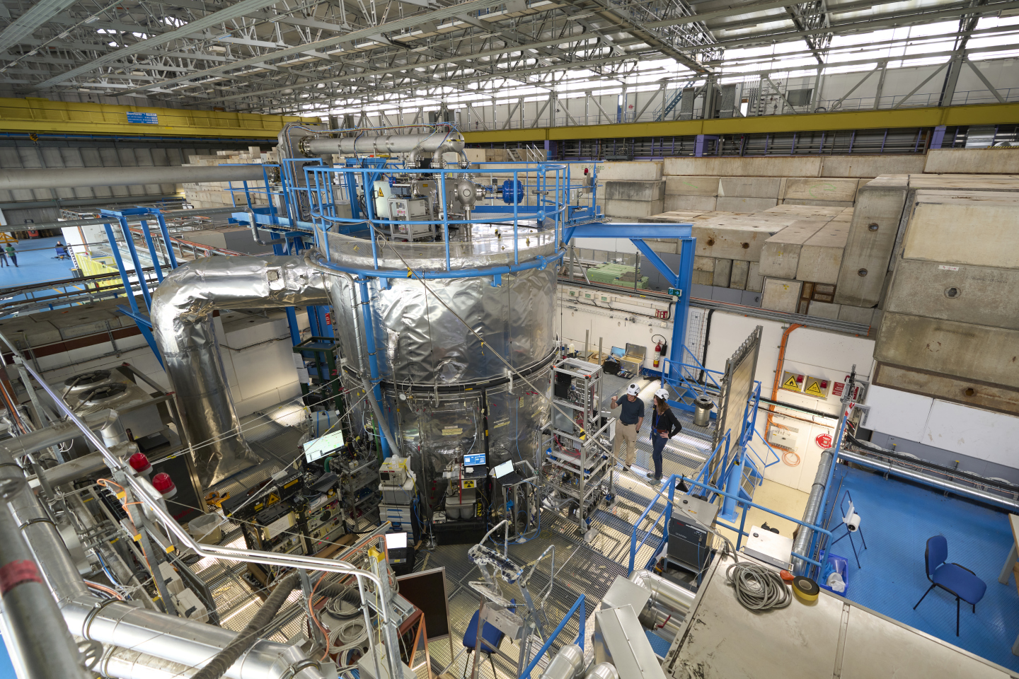
CLOUD discovers new way by which aerosols rapidly form and grow at high altitude��ͼ��
CLOUD ���ܽ� �ߺ��ε��� �����γ�
2023/5/26
Aerosol particles can form and grow in Earth��s upper troposphere in an unexpected way, reports the CLOUD collaboration in a paper1 published today in Nature.
Influence of Drone Altitude, Image Overlap, and Optical Sensor Resolution on Multi-View Reconstruction of Forest Images
UAV drone-based remote sensing geometric image resolution multi-view reconstruction reconstruction efficiency reconstruction quality structure from motion precision forestry
2024/2/4
Recent technical advances in drones make them increasingly relevant and important tools for forest measurements. However, information on how to optimally set flight parameters and choose sensor resolu...
COMPREHENSIVE ANALYSIS OF FLYING ALTITUDE FOR HIGH RESOLUTION SLOPE MAPPING USING UAV TECHNOLOGY
Flying Altitudes Ground Control Point (GCP) High Resolution Imagery 3D Slope Mapping UAV
2018/4/18
Unmanned Aerial Vehicle (UAV) is one of the geoinformation data acquisition technologies that popularly used for slope mapping. UAV is capable to produce high resolution imageries in a short period. I...
COMPREHENSIVE ANALYSIS OF FLYING ALTITUDE FOR HIGH RESOLUTION SLOPE MAPPING USING UAV TECHNOLOGY
Flying Altitudes Ground Control Point (GCP) High Resolution Imagery 3D Slope Mapping UAV
2018/5/8
Unmanned Aerial Vehicle (UAV) is one of the geoinformation data acquisition technologies that popularly used for slope mapping. UAV is capable to produce high resolution imageries in a short period. I...
Assessing the amount of soil organic matter and soil properties in high mountain forests in Central Anatolia and the effects of climate and altitude
forest soil topographic conditions climate model semi-arid regions Turkey
2017/6/26
The objectives of this study were to determine the amounts of soil organic matter (SOM) stored within surface soils of high mountain forests and how the SOM amounts are affected by aridity and altitud...
Nonspecular meteor trail altitude distributions and durations observed by a 50 MHz high�\power radar
durations observed trail altitude distributions
2017/3/22
High�\power large�\aperture (HPLA) radars frequently observe nonspecular meteor trail
echoes that result from plasma turbulence driven by the intense pressure gradients on
the trail edges. This paper ...
RESEARCH ON THE KEY TECHNOLOGY OF LARGE SCALE MAPPING FROM LOW ALTITUDE PHOTOGRAMMETRY
Large-scale Photogrammetry Wide-angle Camera Elevation Accuracy Low Altitude Photogrammetry Production Process Low Altitude Photogrammetric DLG Production Multi-center Image Projection Reconstruction
2016/7/5
Based on the theoretic analysis of the accuracy in large scale photogrammetric mapping, some defects in traditional procedure were discussed. A set of key technologies dedicate to accuracy improvement...
NOVEL APPROACH FOR ESTIMATING NITROGEN CONTENT IN PADDY FIELDS USING LOW ALTITUDE REMOTE SENSING SYSTEM
Low altitude remote sensing Unmanned aerial vehicle Rice Vegetation index Nitrogen
2016/7/5
Concerns over the use of nitrogen have been increasing due to the high cost of fertilizers and environmental pollutions caused by excess nitrogen application in agricultural fields. Several methods ar...
LOW-ALTITUDE UNMANNED AIRSHIP PHOTOGRAMMETRY SYSTEM
Unmanned airship Combined wide-angle low attitude camera low-altitude photogrammetry
2016/3/17
Constrained by the satellites orbits, Satellite Remote Sensing is difficult to achieve timeliness requirements. General aerial manned aircraft Remote Sensing is always delayed by the bad weather.Compa...
Increased Hypoxic Dose After Training at Low Altitude with 9h Per Night at 3000m Normobaric Hypoxia
Hypoxia hemoglobin mass live high: train low athletic performance peak oxygen uptake
2016/2/23
This study examined effects of low altitude training and a live-high: train-low protocol (combining both natural and simulated modalities) on haemoglobin mass (Hbmass), maximum oxygen consumption (VO2...
Photogrammetric Processing of Low Altitude Image Sequences by Unmanned Airship
Image Sequence Close Range Photogrammetry Matching,
2015/12/17
Low altitude aerial image sequences have the advantages of high overlap, multi viewing and very high ground resolution. These
kinds of images can be used in various applications that need high precis...
A Contrast among Experiments in Three Low-altitude Unmanned Aerial Vehicles Photography: Security, Quality & Efficiency
Low altitude Aerial photography Photogrammetry Unmanned helicopter
2015/11/24
At present, the vast majority of photographic measurement units are in a state of "measuring" instead of "photographing". In order to combine "photographing" with "measuring" more closely, an engineer...
UAV for Mapping-Low Altitude Photogrammetric Survey
Photogrammetry Mapping UAV Automatic Aerial Triangulation Camera Calibration
2015/11/24
Two kinds of platform are accepted for mapping UAV system. One is remotely-piloted aircraft. Another is unmanned helium airship.A super-wide-angle camera is constructed by four digital cameras, mounte...
Actualize of Low Altitude Large Scale Aerophotography and Geodesic base on Fixed-Wing Unmanned Aerial Vehicle Platform
System Integration Aerial Photogrammetry Digital Orthophoto Orthophoto Mapping Aerial Triangulation
2015/11/23
This paper introduces the key technologies and methods of establishing the aerial photogrammetric system using Unmanned Aerial Vehicles (UVA) photogrammetry technique for satisfying the increasing nee...
Design and Actualization of the Aerial Photogrammetric System of the Low Altitude Unmanned Biplane
Autonomous Navigation Aerial Photography Non-Metric Digital Camera Calibration
2015/11/23
This paper designs and actualizes independently a set of the aerial photogrammetric system by the low altitude unmanned biplane for satisfying with the request of three-dimensional stereoplotting and ...
�й��о����������а�-��
- ���ڼ���...
�й�ѧ���ڿ����а�-��
- ���ڼ���...
�����ѧ���л������а�-��
- ���ڼ���...
�й���ѧ���а�-��
- ���ڼ���...
�ˡ���-ƪ
- ���ڼ���...
�Ρ���-ƪ
- ���ڼ���...
��������-ƪ
- ���ڼ���...
�������� -ƪ
- ���ڼ���...
֪ʶҪ��-ƪ
- ���ڼ���...
���ʶ�̬-ƪ
- ���ڼ���...
��������-ƪ
- ���ڼ���...
ѧ��ָ��-ƪ
- ���ڼ���...
ѧ��վ��-ƪ
- ���ڼ���...