
搜索结果: 1-15 共查到“Elevation”相关记录174条 . 查询时间(0.1 秒)
Land-Cover and Elevation-Based Mapping of Aboveground Carbon in a Tropical Mixed-Shrub Forest Area in West Java, Indonesia
aboveground biomass geostatistics kriging regression modeling stratification tropical forest
2024/1/23
Carbon sequestration and storage are among the most important ecosystem services provided by tropical forests. Improving the accuracy of the carbon mapping of tropical forests has always been a challe...
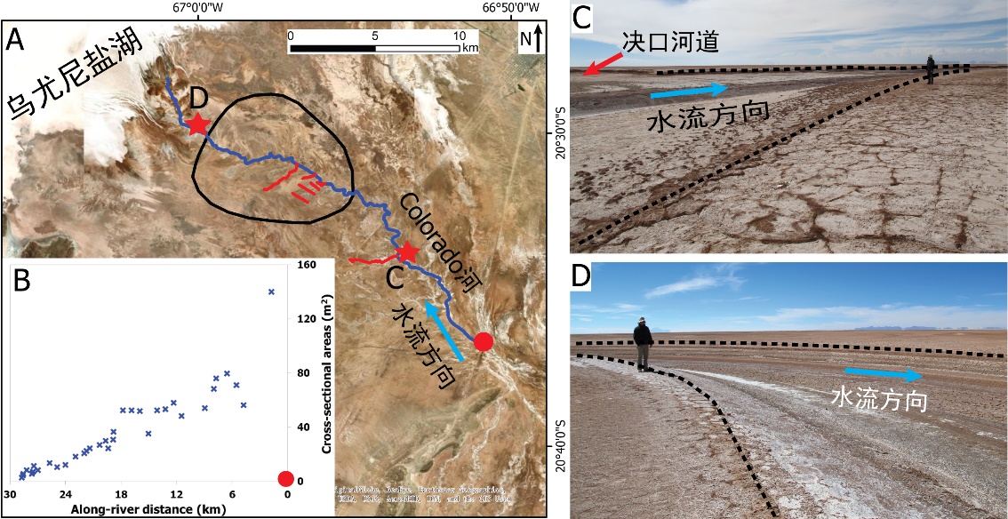
中国地质大学科学技术发展院李嘉光* 等,资源学院. Journal of Hydrology(2020), Digital Elevation Models for topographic characterisation and flood flow modelling along low-gradient, terminal dryland rivers: A comparison of spaceborne datasets for the Río Colorado, Bolivia(图)
精确表征;极低;缓河流;末端;地形;模拟河道;洪水;漫溢
2021/10/15
近日,国际知名期刊Journal of Hydrology在线刊发了中国地质大学资源学院李嘉光副教授团队在陆相湖盆边缘河流末端沉积体系研究的最新成果――Digital Elevation Models for topographic characterisation and flood flow modelling along low-gradient, terminal dryland rive...
Differential Trends of Qinghai Spruce Growth with Elevation in Northwestern China during the Recent Warming Hiatus
Qinghai spruce warming hiatus elevation gradient tree growth growth-climate relationships
2024/3/4
Tree growth strongly responds to climate change, especially in semiarid mountainous areas. In recent decades, China has experienced dramatic climate warming; however, after 2000 the warming trend subs...
TOPOLOGICAL 3D ELEVATION DATA INTERPOLATION OF ASTER GDEM BASED ON CONTINUOUS DEFORMATION
Homotopy continuation 3D Data Interpolation DEM Optimization
2018/11/9
In Geographic Information Science, polynomial methods such as linear estimation and non-polynomial methods including Inverse Distance Weighting and Kriging have been used for elevation data interpolat...
COMPARISON AND ANALYSIS OF ACCURACY OF ELEVATION EXTRACTION BASED ON THE ZY-3 01 AND 02 SATELLITES STEREOSCOPIC IMAGES
ZY-3 Stereoscopic Satellite GSD DEM differential DEM, Accuracy
2018/5/16
The ZY-3 is the civil high-resolution optical stereoscopic mapping satellite independently developed by China. The ZY-3 constellation of the twin satellites operates in a sun-synchronous, near-polar, ...
THE RESEARCH ON ELEVATION CHANGE OF ANTARCTIC ICE SHEET BASED ON CRYOSAT-2 ALIMETER
Antarctic Ice Sheet, Cryosat-2,Satellite Altimetry,DEM, Crossover Adjustment,Kriging Interpolation, Intersection
2018/5/15
In this paper, the Cryosat-2 altimeter data distributed by the ESA, and these data are processed to extract the information of the elevation change of the Antarctic ice sheet from 2010 to 2017. Firstl...
SUBAQUATIC DIGITAL ELEVATION MODELS FROM UAV-IMAGERY
UAV, DEM underwater multi-media bundle-adjustment
2018/6/4
The paper presents an approach for the generation of digital elevation models (DEMs) of underwater areas from aerial images. Standard software-products do not provide the possibility to measure correc...
A MULTI-RESOLUTION FUSION MODEL INCORPORATING COLOR AND ELEVATION FOR SEMANTIC SEGMENTATION
Semantic Segmentation Convolutional Networks Multi-modal Dataset Fusion Nets
2017/7/13
In recent years, the developments for Fully Convolutional Networks (FCN) have led to great improvements for semantic segmentation in various applications including fused remote sensing data. There is,...
VERTICAL ACCURACY COMPARISON OF DIGITAL ELEVATION MODEL FROM LIDAR AND MULTITEMPORAL SATELLITE IMAGERY
Vertical Accuracy LiDAR DEM Multitemporal Stereo Satellite Imagery DEM
2017/7/13
Digital elevation model serves to illustrate the appearance of the earth's surface. DEM can be produced from a wide variety of data sources including from radar data, LiDAR data, and stereo satellite ...
Tropical lowland frogs at greater risk from climate warming than high-elevation species,study shows
Tropical lowland frogs greater risk climate warming high-elevation species
2017/4/27
A new study of Peruvian frogs living at a wide variety of elevations―from the Amazon floodplain to high Andes peaks―lends support to the idea that lowland amphibians are at higher risk from future cli...
EXPLORING THE CONNECTIVITY OF ECOLOGICAL CORRIDORS BETWEEN LOW ELEVATION MOUNTAINS AND PINGTUNG LINHOUSILIN FOREST PARK OF TAIWAN BY LEAST-COST PATH METHOD
Linhousilin Forest Park Landscape ecology Least-cost path Gravity model
2016/11/30
The primary purpose of this study was explored the variation of landscape process and its impact on the possibility of ecological corridors on Pingtung Linhousilin Forest Park. Developing the landscap...
VEGETATION COVER MAPPING BASED ON REMOTE SENSING AND DIGITAL ELEVATION MODEL DATA
Geographic Information System (GIS) Remote Sensing (RS) Digital Elevation Model (DEM) Vegetation Mapping
2016/11/30
An algorithm of forest cover mapping based on combined GIS-based analysis of multi-band satellite imagery, digital elevation model, and ground truth data was developed. Using the classification princi...
FIELD SPECTROSCOPY FOR VEGETATION EVALUATION ALONG THE NUTRIENT AND ELEVATION GRADIENT ABOVE THE TREE LINE IN THE KRKONOŠE MOUNTAINS NATIONAL PARK
field spectroscopy plant cover fAPAR nutrient and elevation gradient tundra The Krkonoš e Mountains National Park
2016/11/15
This paper examines the relations between vegetation spectra measured in the field along the nutrient and elevation gradient in the most valuable parts of The Krkonoše Mountains tundra and select...
DETERMINING THE SUITABILITY OF DIFFERENT DIGITAL ELEVATION MODELS AND SATELLITE IMAGES FOR FANCY MAPS. AN EXAMPLE OF CYPRUS
Fancy map Image DEM Relief shading hillshading image merge color composite
2016/11/8
The article describes the possibility of developing an overall map of the selected area on the basis of publicly available data. Such a map would take the form designed by the author with the colors t...
VALIDATION OF THE ASTER GLOBAL DIGITAL ELEVATION MODEL VERSION 3 OVER THE CONTERMINOUS UNITED STATES
Accuracy DEM/DTM Comparison Geodesy Global-Environmental-Databases Land Cover Mapping Satellite
2016/11/8
The ASTER Global Digital Elevation Model Version 3 (GDEM v3) was evaluated over the conterminous United States in a manner similar to the validation conducted for the original GDEM Version 1 (v1) in 2...