搜索结果: 1-15 共查到“Kriging”相关记录64条 . 查询时间(0.093 秒)

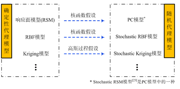
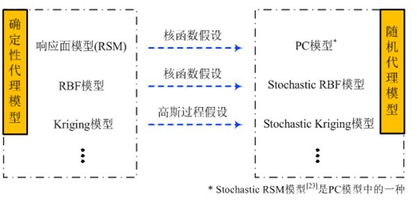
梯度增强的Stochastic Co-Kriging模型建模及其在CFD非嵌入式不确定性量化中应用的研究进展(图)
梯度增强 Stochastic Co-Kriging 模型建模 CFD 非嵌入式 不确定性
2019/10/30
作为一项极其复杂的系统工程,飞行器的研制总会受到制造误差、飞行状态等诸多不确定性因素的影响,如果这些不确定性因素在设计过程中被忽视,很可能会导致飞行器整体性能急剧变差,甚至造成致命性的灾难。因此,近年来飞行器的不确定性研究方法和手段在航空航天领域得到了广泛应用,NASA早在2002年就开始着手规划考虑不确定性因素影响的研究工作,AIAA和ASME每年都举办关于不确定性研究的专题研讨会。当前我国各型...

梯度增强的Stochastic Co-Kriging模型建模及其在CFD非嵌入式不确定性量化中应用的研究进展(图)
梯度增强 Stochastic Co-Kriging 模型建模 CFD非嵌入式 不确定性量化
2019/10/16
作为一项极其复杂的系统工程,飞行器的研制总会受到制造误差、飞行状态等诸多不确定性因素的影响,如果这些不确定性因素在设计过程中被忽视,很可能会导致飞行器整体性能急剧变差,甚至造成致命性的灾难。因此,近年来飞行器的不确定性研究方法和手段在航空航天领域得到了广泛应用,NASA早在2002年就开始着手规划考虑不确定性因素影响的研究工作,AIAA和ASME每年都举办关于不确定性研究的专题研讨会。当前我国各型...
FUSION OF HYPERSPECTRAL AND MULTISPECTRAL IMAGERY WITH REGRESSION KRIGING AND THE LULU OPERATORS; A COMPARISON
Image fusion Regression Kriging LULU operators Classification, Slums
2019/2/28
In this digital world, there is a large requirement of high resolution satellite image. Images at a low resolution may contain relevant information that has to be integrated with the high resolution i...
提出了一种基于主动学习Kriging的飞行器射程评估方法;结合高超声速飞行器的特点,通过将气动、推进、质量学科的不确定性因素注入飞行器设计多学科分析模型,构建飞行器射程概率评估模型;进而,利用主动学习策略序列加点方法建立射程评估代理模型,实现对射程及设计裕度的量化分析;仿真结果表明:该方法合理可行,显著提升了射程评估效率。
IMPLEMENTATION OF KRIGING METHODS IN MOBILE GIS TO ESTIMATE DAMAGE TO BUILDINGS IN CRISIS SCENARIOS
Kriging methods Mobile GIS natural hazard
2016/7/8
In the paper an example for the application of kriging methods to estimate damage to buildings in crisis scenarios is introduced. Furthermore, the Java implementations for Ordinary and Universal Krigi...
Rasterizing Airborne Laser Scanning Point Clouds by Block Kriging
Airborne laser scanning Point clouds Rasterization Block Kriging Geostatistics
2015/12/9
Airborne laser scanning (ALS) is increasingly becoming a standard method for the collection of dense elevation models, especially in 3D urban mapping. However, automation in processing of ALS point-cl...
Revealing celtic fields from LIDAR data using Kriging based filtering
LIDAR archaeology ltering geostatistics
2015/8/25
A detailed elevation model of the Netherlands has been acquired with the use of Airborne Laser Altimetry and is managed by AHN(Actueel Hoogtebestand Nederland). This elevation model can be used for a ...
We propose a method with better predictions at extreme values than
the standard method of Kriging. We construct our predictor in two ways:
by penalizing the mean squared error through conditional bi...
Kriging of Groundwater Levels – A Case Study
Geostatistics Groundwater levels Semivariogram Kriging India
2015/8/11
In this paper, application of the spatial statistical technique, kriging, for the spatial analysis of groundwater levels is shown. The data set consists of groundwater levels measured at about 60 poin...
Estimation of Aquifer Transmissivity using Kriging, Artificial Neural Network, and Neuro-Fuzzy models
ransmissivity Kriging Artificial Neural Network ANFIS Neuro-Fuzzy interpolation groundwater
2015/8/11
In interpolation of groundwater properties such as transmissivity, due to the unknown distributed values of the variables and heterogenity, the best and the unbiased aspects are frequently difficult t...
Modelling Local Gps/levelling Geoid with The Assesstment of Inverse Distance Weighting and Geostatistical Kriging Methods
Geodesy Modelling DEM/DTM
2015/7/6
According to wide spread use of satellite based positioning techniques, especially GPS (Global Positioning System), a greater
attention has started to be paid to precise determination of geoid models...
An Ionosphere Estimation Algorithm for WAAS Based on Kriging
Ionosphere Estimation Algorithm WAAS Based Kriging
2015/6/26
GPS alone cannot provide the integrity needed for air navigation. Several error sources deteriorate the precision of the position estimate. One of the largest and more unpredictable sources of error f...
Adapting Kriging to the WAAS MOPS Ionospheric Grid
Adapting Kriging WAAS MOPS Ionospheric Grid
2015/6/26
The most productive way to increase the availability of single frequency users of the Wide Area Augmentation System (WAAS) is by decreasing the Grid Ionospheric Vertical Error (GIVE). Currently the GI...
Ionospheric Estimation using Extended Kriging for a low latitude SBAS
Ionospheric Estimation Extended Kriging latitude SBAS
2015/6/26
The ionosphere causes the most difficult error to mitigate in Satellite Based Augmentation Systems (SBAS). The problem has been solved for the mid latitude regions using the thin shell approximation. ...
A New Ionospheric Estimation Algorithm for SBAS Combining Kriging and Tomography
Ionospheric Estimation Algorithm SBAS Combining Kriging Tomography
2015/6/26
One can divide the existing ionospheric methods for SBAS in two categories: tomography and methods relying on the thin shell model. At first sight, tomography appears to be the right choice. Tomograph...

