
搜索结果: 1-15 共查到“工学 Satellite data”相关记录103条 . 查询时间(0.109 秒)
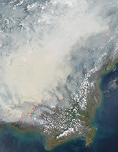
Satellite data can reveal fire susceptibility in peatlands(图)
Satellite data fire susceptibility peatlands
2019/10/18
When large areas of carbon-rich soil catch fire, the blaze emits massive amounts of carbon into the atmosphere and creates a thick haze. These blazes can usher in long-term climate impacts that affect...
EXTRACTION OF BLUE ICE AREA USING ALBEDO VALUE DERIVED FROM LANDSAT-8 SATELLITE DATA
Blue Ice Landsat-8 Albedo Polar record Glacier Image Processing
2019/2/28
Blue Ice Areas (BIAs) or bare ice areas are zones of glacier where surface mass balance is negative, sublimation forms the major ablation process and surface albedo is relatively small. Exceptionally ...
SNOW COVER MAPPING AND ICE AVALANCHE MONITORING FROM THE SATELLITE DATA OF THE SENTINELS
Snow Cover Ice Avalanche Sentinels
2018/5/15
In order to monitor ice avalanches efficiently under disaster emergency conditions, a snow cover mapping method based on the satellite data of the Sentinels is proposed, in which the coherence and bac...
RETRIEVAL OF ATMOSPHERIC PARTICULATE MATTER USING SATELLITE DATA OVER CENTRAL AND EASTERN CHINA
Retrieval Atmospheric Particulate Matter Satellite Central and Eastern China
2018/5/11
Fine particulate matter (PM2.5) is a particle cluster with diameters less than or equal to 2.5 μm. Over the past few decades, regional air pollution composed of PM2.5 has frequently occurred ove...
URBAN BUILT-UP AREA EXTRACTION AND APPLICATION BASED ON GF-2 SATELLITE DATA
GF-2 satellite object-oriented method built-up area Shennongjia
2018/5/16
GF-2 satellite was launched in China on August 19, 2014. It has wide potential applications with the spatial resolution of around 1 meter. In this paper, urban built-up area was extracted and classifi...
FOSS4G DATE ASSESSMENT ON THE ISPRS OPTICAL STEREO SATELLITE DATA: A BENCHMARK FOR DSM GENERATION
Cartosat-1 Worldview-1 DSM Matching Accuracy FOSS4G
2017/7/13
The ISPRS Working Group 4 Commission I on “Geometric and Radiometric Modelling of Optical Spaceborne Sensors”, provides a benchmark dataset with several stereo data sets from space borne stereo sensor...
THE BENEFITS AND CHALLENGES OF HAVING AN OPEN AND FREE BASIS SATELLITE DATA SHARING PLATFORM IN TURKEY:GEZGİN
RASAT GEZGIN Satellite data sharing platform
2016/12/1
Turkey is a county that experiences rapid socioeconomic development, which, in turn, leads to high urbanization rates due to migration of people from rural to urban areas, many large-scale development...
IDENTIFYING LOCAL SCALE CLIMATE ZONES OF URBAN HEAT ISLAND FROM HJ-1B SATELLITE DATA USING SELF-ORGANIZING MAPS
Urban heat island Local climate zones Impervious surface area Land surface temperature Surface albedo Self-organization maps
2016/12/1
With the increasing acceleration of urbanization, the degeneration of the environment and the Urban Heat Island (UHI) has attracted more and more attention. Quantitative delineation of UHI has become ...
RICE YIELD ESTIMATION THROUGH ASSIMILATING SATELLITE DATA INTO A CROP SIMUMLATION MODEL
Data assimilation remote sensing crop simulation model rice yield
2016/12/1
Rice is globally the most important food crop, feeding approximately half of the world’s population, especially in Asia where around half of the world’s poorest people live. Thus, advanced spatiotempo...
USING SATELLITE DATA FOR ENVIRONMENTAL IMPACT ANALYSIS IN ECONOMIC GROWTH:THE CASE OF MONGOLIA
Satellite Data Environmental Impact Analysis Economic growth The Green Solow model The Ramsey- Cass- Koopmans model
2016/12/1
The Mongolian economy is based on the primary and secondary economic sectors of agriculture and industry. In addition, minerals and mining become a key sector of its economy. The main mining resources...
PRECISION VITICULTURE FROM MULTITEMPORAL,MULTISPECTRAL VERY HIGH RESOLUTION SATELLITE DATA
Vineyards Crop Management Selective Harvesting Oenological potential Phenolic composition
2016/12/1
In order to exploit efficiently very high resolution satellite multispectral data for precision agriculture applications, validated methodologies should be established which link the observed reflecta...
AUTOMATIC EXTRACTION OF MANGROVE VEGETATION FROM OPTICAL SATELLITE DATA
Mangroves LISS Landsat 8 segmentation pixel value gabor filtering Otsus method
2016/11/30
Mangrove, the intertidal halophytic vegetation, are one of the most significant and diverse ecosystem in the world. They protect the coast from sea erosion and other natural disasters like tsunami and...
SHORT-TERM PRECIPITATION OCCURRENCE PREDICTION FOR STRONG CONVECTIVE WEATHER USING FY2-G SATELLITE DATA: A CASE STUDY OF SHENZHEN,SOUTH CHINA
Short-term precipitation SVM FY-2G satellite image Precipitation occurrence prediction
2016/11/15
Short-term precipitation commonly occurs in south part of China, which brings intensive precipitation in local region for very short time. Massive water would cause the intensive flood inside of city ...
APPLICATION OF THE TERRA MODIS SATELLITE DATA FOR ENVIRONMENTAL MONITORING IN WESTERN SIBERIA
Environment Satellite Images Geographic Information Systems Oil Fields
2016/11/15
Using the MODIS thematic products, the status of vegetation of oil producing areas in Western Siberia for the period 2010-2015 is monitored. An approach for estimating the impact of various factors on...
ADVANCED EXTRACTION OF SPATIAL INFORMATION FROM HIGH RESOLUTION SATELLITE DATA
Image Analysis Seath Obia Satellite Imagery Urban Areas
2016/7/28
In this paper authors processed five satellite image of five different Middle-European cities taken by five different sensors. The aim of the paper was to find methods and approaches leading to evalua...