搜索结果: 1-15 共查到“工学 Forests”相关记录84条 . 查询时间(0.082 秒)

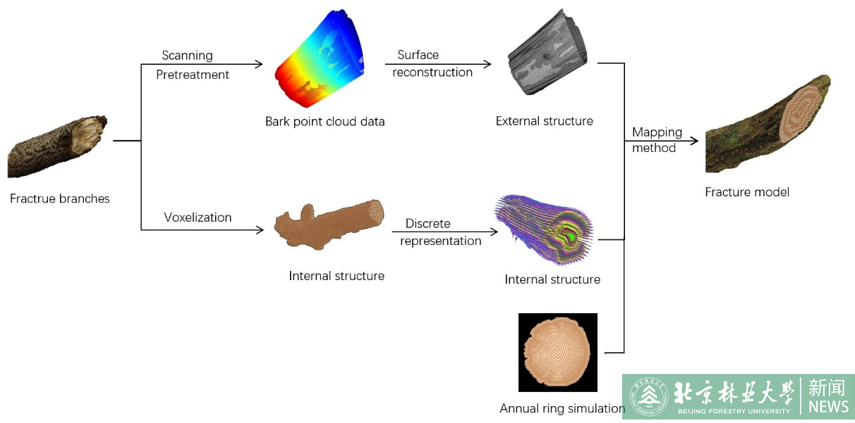
2023年6月28日,《Forests》(中科院期刊分区表大类二区,IF=3.282)刊发了2023年最新一期(Volume 14, Issue 5)的文章,我校信息学院杨猛课题组论文《Visualization Simulation of Branch Fractures Based on Internal Structure Reconstruction》被选为本期的“Feature Pape...
3-D STRUCTURE OF INDIAN FORESTS – PERSPECTIVES FROM EXPERIMENTS ON THE FIRST FULLY-POLARIMETRIC TANDEM-X TOMOGRAMS
Radar Tomography SAR TanDEM-X Forest India Tropical Structure
2019/2/27
This paper provides a first hand view of the 3-D structure of the forests when viewed by X-band SAR data. Tomograms are generated using multi-polarimetric space-borne TerraSAR-X/TanDEM-X acquisitions ...
Gap characteristics under oriental beech forest development stages in Kelardasht forests, northern Iran
close-to-nature silviculture forest stand stand dynamics gapmaker silviculture
2018/3/6
This study was carried out to evaluate gap characteristics and gapmakers for different development stages of an oriental
beech forest in northern Iran. Development stages of 1 ha square-shaped mosaic...
Estimating the aboveground carbon sequestration and its economic value (case study: Iranian Caspian forests)
allometric equation economic value of carbon density of wood forest inventory
2018/3/6
The aim of the study is to estimate the aboveground carbon sequestration and to determine the economic
value of forests in carbon sequestration as a way of mitigating climate change. This research wa...
ESTIMATING CARBON STOCK CHANGES OF MANGROVE FORESTS USING SATELLITE IMAGERY AND AIRBORNE LiDAR DATA IN THE SOUTH SUMATRA STATE,INDONESIA
LiDAR Satellite imagery Biomass Carbon stock change Mangrove forest
2016/11/30
The purposes of this study were 1) to estimate the biomass in the mangrove forests using satellite imagery and airborne LiDAR data, and 2) to estimate the amount of carbon stock changes using biomass ...
ABILITY OF LANDSAT-8 OLI DERIVED TEXTURE METRICS IN ESTIMATING ABOVEGROUND CARBON STOCKS OF COPPICE OAK FORESTS
Operational Land Imager Co-occurrence Matrix Aboveground Carbon Stocks Stepwise Regression
2016/11/30
The role of forests as a reservoir for carbon has prompted the need for timely and reliable estimation of aboveground carbon stocks. Since measurement of aboveground carbon stocks of forests is a dest...
MAPPING DISTURBANCE DYNAMICS IN WET SCLEROPHYLL FORESTS USING TIME SERIES LANDSAT
forest disturbance Central Highlands open-source random forests timber harvesting fire
2016/11/30
In this study, we characterised the temporal-spectral patterns associated with identifying acute-severity disturbances and low-severity disturbances between 1985 and 2011 with the objective to test wh...
KERNEL FEATURE CROSS-CORRELATION FOR UNSUPERVISED QUANTIFICATION OF DAMAGE FROM WINDTHROW IN FORESTS
Feature matching Kernel normalized cross-correlation Forest Support Vector Machines
2016/11/23
In this study estimation of tree damage from a windthrow event using feature detection on RGB high resolution imagery is assessed. An accurate quantitative assessment of the damage in terms of volume ...
Relation between selected indicators of forest stand diversity and quality of timber production in managed Central European forests
assortment species diversity structural diversity timber quality
2016/4/6
The present study examines the relationship between the quality of timber production and the species and structural diversity of forest stands. The data used came from a regional forest inventory of t...
SPECTRORADIOMETRIC MEASUREMENTS OF TREE SPECIES IN THE CASPIAN FORESTS OF IRAN
Field Spectroradiometry spectral signatures vegetation indices Caspian forest Illumination Iran
2015/12/30
Forest type maps play a significant role in sustainable forest management. For many years aerial photos and satellite data were a primary data source supporting forest type mapping. Recent development...
TOWARDS 3D MAPPING OF FORESTS:A COMPARATIVE STUDY WITH FIRST/LAST PULSE AND FULL WAVEFORM LIDAR DATA
LIDAR Analysis Segmentation Forestry Vegetation
2015/12/29
This paper highlights several approaches to segment and reconstruct trees from LIDAR data and compares the results acquired both from first/last pulse and full waveform data. In a first step, we set u...
Exploring the Measurement Of Forests With Full Waveform LIDAR through Monte-Carlo Ray Tracing
Forestry structure lidar vegetation simulation 3D modelling satellite
2015/11/20
The error of the height estimates are precisely quantified by comparison with the 3D model height. This paper discusses the development and testing of the inversion of tree height from simulations of ...
DEVELOPMENT OF A PROCEDURE FOR VERTICAL STRUCTURE ANALYSIS AND 3D-SINGLE TREE EXTRACTION WITHIN FORESTS BASED ON LIDAR POINT CLOUD
Canopy Vertical structure Tree crown 3D model Lidar Point cloud
2015/11/10
A procedure for both vertical canopy structure analysis and 3D single tree extraction based on Lidar raw point cloud is presented in this paper. The whole study area is segmented into small study cell...
TERRESTRIAL LASER SCANNING VERSUS TRADITIONAL FOREST INVENTORY FIRST RESULTS FROM THE POLISH FORESTS
terrestrial laser scanning DBH tree and stand basal area manual and automatic methods
2015/11/10
The goal of this paper was to present the pilot study ongoing in the Polish State Forests on the application of gathering basic forest parameters using the terrestrial laser scanner (TLS) technology. ...
ASSESSMENT OF LIDAR-DERIVED TREE HEIGHTS ESTIMATED FROM DIFFERENT FLIGHT ALTITUDE DATA IN MOUNTAINOUS FORESTS WITH POOR LASER PENETRATION RATES
Forestry Remote Sensing LIDAR Laser scanning DEM/DTM
2015/11/10
In this study, the effects of different flight altitudes on tree height estimates with a small-footprint scanning lidar were investigated and assessed in mountainous forests with poor laser penetratio...

