
�������: 1-15 ���鵽����ѧ spaceborne����ؼ�¼15�� . ��ѯʱ��(0.156 ��)
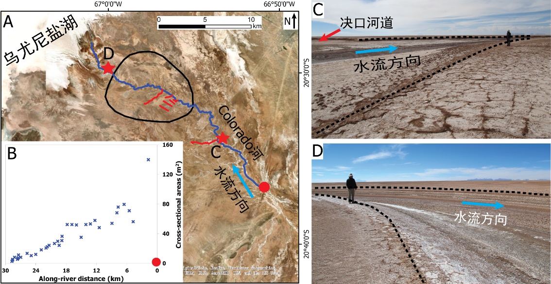
�й����ʴ�ѧ��ѧ������չԺ��ι�* �ȣ���ԴѧԺ. Journal of Hydrology��2020��, Digital Elevation Models for topographic characterisation and flood flow modelling along low-gradient, terminal dryland rivers: A comparison of spaceborne datasets for the R��o Colorado, Bolivia��ͼ��
��ȷ���������ͣ���������ĩ�ˣ����Σ�ģ��ӵ�����ˮ������
2021/10/15
���գ�����֪���ڿ�Journal of Hydrology���߿������й����ʴ�ѧ��ԴѧԺ��ι⸱�����Ŷ���½������Ե����ĩ�˳�����ϵ�о������³ɹ�����Digital Elevation Models for topographic characterisation and flood flow modelling along low-gradient, terminal dryland rive...
SYNOPTIC OBSERVATIONS OF CALVING EVENTS IN ANTARCTICA USING SPACEBORNE IMAGES
Antarctica Calving Optical Images Rifts Icebergs
2019/2/28
Iceberg calving is the detachment of ice from ice shelves or glaciers. Although calving is a natural phenomenon, an abnormal rate of calving can be a threat to ice shelves. Some of the events were so ...
COMPARISON OF SPACEBORNE AND AIRBORNE HYPERSPECTRAL IMAGING SYSTEMS FOR ENVIRONMENTAL MAPPING
Remote Sensing Hyperspectral Comparison Platforms Land Cover Mapping
2015/7/30
The main purpose of this study was to compare hyperspectral remotely sensed data collected by the Hyperion satellite, and the
airborne Real-time Data Acquisition Camera System (RDACS-3) and the Airb...
THE FUTURE SPACEBORNE HYPERSPECTRAL IMAGER ENMAP: ITS IN-FLIGHT RADIOMETRIC AND GEOMETRIC CALIBRATION CONCEPT
Geometric Calibration Radiometric Calibration Hyper spectral Satellite
2014/4/25
The German Aerospace Center DLR �C namely the Earth Observation Center EOC and the German Space Operations Center GSOC �C is responsible for the establishment of the ground segment of the future German ...
Applying Advanced Spaceborne Thermal Emission and Reflection Radiometer (ASTER) spectral indices for geological mapping and mineral identification on the Tibetan Plateau
ASTER Thermal Mapping Spectral indices Ultramafic Ophiolite Tibetan Plateau
2011/8/5
Abstract: The Tibetan Plateau holds clues to understanding the dynamics and mechanisms associated with continental growth. Part of the region is characterized by zones of ophiolitic melange believed t...
Potential of high-resolution detection and retrieval of precipitation fields from X-band spaceborne synthetic aperture radar over land
high-resolution detection retrieval precipitation fields X-band spaceborne synthetic
2011/3/15
X-band Synthetic Aperture Radars (X-SARs), able to image the Earth's surface at metric resolution, may provide a unique opportunity to measure rainfall over land with spatial resolution of about few ...
EnKF assimilation of simulated spaceborne Doppler observations of vertical velocity: impact on the simulation of a supercell thunderstorm and implications for model-based retrievals
EnKF velocity
2010/1/27
Recently, a number of investigations have been made that point to the robust effectiveness of the Ensemble Kalman Filter (EnKF) in convective-scale data assimilation. These studies have focused on the...
The continental source of glyoxal estimated by the synergistic use of spaceborne measurements and inverse modelling
glyoxal spaceborne measurements inverse modelling
2009/11/19
Tropospheric glyoxal and formaldehyde columns retrieved from the SCIAMACHY satellite instrument in 2005 are used with the IMAGESv2 global chemistry-transport model and its adjoint in a two-compound in...
The Utilization of Spaceborne Microwave Radiometers for Monitoring Snowpack Properties
Utilization Spaceborne Microwave Radiometers Snowpack Properties
2009/10/29
Snow accumulation and depletion at specific locations can be monitored from
space by observing related variations in microwave brightness temperatures.
Using vertically and horizontally polarized br...
New perspectives on gravity wave remote sensing by spaceborne infrared limb imaging
New perspectives gravity wave remote sensing spaceborne infrared limb imaging
2010/2/8
Gravity wave (GW) remote sensing from space now has reached a stage of maturity that some first confinements for GW modeling can be deduced. This is in particular due to global distributions of absolu...
Global carbon monoxide vertical distributions from spaceborne high-resolution FTIR nadir measurements
Global carbon monoxide vertical distributions spaceborne high-resolution FTIR nadir
2009/1/14
This paper presents the first global distributions of CO vertical profiles retrieved from a thermal infrared FTS working in the nadir geometry. It is based on the exploitation of the high resolution a...
Characterization of Polar Stratospheric Clouds with spaceborne lidar: CALIPSO and the 2006 Antarctic season
Polar Stratospheric Cloud spaceborne lidar CALIPSO Antarctic season
2008/12/22
The role of polar stratospheric clouds in polar ozone loss has been well documented. The CALIPSO satellite mission offers a new opportunity to characterize PSCs on spatial and temporal scales previou...
Identification of glacier motion and potentially dangerous glacial lakes in the Mt. Everest region/Nepal using spaceborne imagery
glacier motion potentially dangerous glacial lakes spaceborne imagery
2010/1/4
Failures of glacial lake dams can cause outburst floods and represents a serious hazard. The potential danger of outburst floods depends on various factors like the lake's area and volume, glacier cha...
Transport pathways of CO in the African upper troposphere during the monsoon season: a study based upon the assimilation of spaceborne observations
CO African upper troposphere monsoon season spaceborne
2008/11/11
The transport pathways of carbon monoxide (CO) in the African Upper Troposphere (UT) during the West African Monsoon (WAM) is investigated through the assimilation of CO observations by the Aura Micro...
CO measurements from the ACE-FTS satellite instrument: data analysis and validation using ground-based, airborne and spaceborne observations
ACE-FTS satellite airborne spaceborne observation
2008/11/6
The Atmospheric Chemistry Experiment (ACE) mission was launched in August 2003 to sound the atmosphere by solar occultation. Carbon monoxide (CO), a good tracer of pollution plumes and atmospheric dyn...
�й��о����������а�-��
- ���ڼ���...
�й�ѧ���ڿ����а�-��
- ���ڼ���...
�����ѧ���л������а�-��
- ���ڼ���...
�й���ѧ���а�-��
- ���ڼ���...
�ˡ���-ƪ
- ���ڼ���...
�Ρ���-ƪ
- ���ڼ���...
��������-ƪ
- ���ڼ���...
�������� -ƪ
- ���ڼ���...
֪ʶҪ��-ƪ
- ���ڼ���...
���ʶ�̬-ƪ
- ���ڼ���...
��������-ƪ
- ���ڼ���...
ѧ��ָ��-ƪ
- ���ڼ���...
ѧ��վ��-ƪ
- ���ڼ���...